Camp Arowhon - Algonquin Park
 I received an urgent note from Ed Hicks of Orienteering Unlimited
in May asking if I could squeeze in a small project before the end
of June. I was pretty busy but when I heard that it was at a beautiful
camp in Algonquin Park I had to say yes. He accepted my cost proposal
and my estimate that I could complete it at sprint standard in less
than one week. It was important that it be completed before camp
officially opened and the first 450 kids and all the 150 counselors moved into
camp.As it turned out, it was a wonderful setting and I
socialized with many of the enthusiastic staff members. They had been
looking forward to a good orienteering map to support their adventure
programs in the summer and fall.
I received an urgent note from Ed Hicks of Orienteering Unlimited
in May asking if I could squeeze in a small project before the end
of June. I was pretty busy but when I heard that it was at a beautiful
camp in Algonquin Park I had to say yes. He accepted my cost proposal
and my estimate that I could complete it at sprint standard in less
than one week. It was important that it be completed before camp
officially opened and the first 450 kids and all the 150 counselors moved into
camp.As it turned out, it was a wonderful setting and I
socialized with many of the enthusiastic staff members. They had been
looking forward to a good orienteering map to support their adventure
programs in the summer and fall.
 However,
my dreams of relaxing at the end of the day with a nice swim and/or
cruise around the lake in a kayak were never realized. There was a
topographically accurate 10-year old property map but it was
missing half of the 100+
buildings and the clearings were not well defined. As well, the twisty
hiking trails had to be plotted from scratch. It took a full six days
of work to complete the map. Somewhat more than I had proposed for the
0.6 sq. Km area, but I also provided some cartographic "extras" that
the client really appreciated. I explain below.A couple of "extras" that I
enjoyed were the camp meals and a private little cabin by the lake. I
didn't take the picture at right but it looks like it was taken out my
back window. The loons would cry all evening and in the mornings they
would be floating by even closer than this one appears. Perfectly at
ease with the people in the camp.
However,
my dreams of relaxing at the end of the day with a nice swim and/or
cruise around the lake in a kayak were never realized. There was a
topographically accurate 10-year old property map but it was
missing half of the 100+
buildings and the clearings were not well defined. As well, the twisty
hiking trails had to be plotted from scratch. It took a full six days
of work to complete the map. Somewhat more than I had proposed for the
0.6 sq. Km area, but I also provided some cartographic "extras" that
the client really appreciated. I explain below.A couple of "extras" that I
enjoyed were the camp meals and a private little cabin by the lake. I
didn't take the picture at right but it looks like it was taken out my
back window. The loons would cry all evening and in the mornings they
would be floating by even closer than this one appears. Perfectly at
ease with the people in the camp.

The
field checking was reasonably straight forward except for base map
buildings that had "disappeared" and replaced by one or more new ones.
In this section of the map many of the buildings were new since the base map or had been
relocated. Measuring the dimensions and layout of the new buildings
took a lot of time. Note to self: Never start another sprint scale map
project without high resolution and current set of
air photos. Orthophotos preferred. Taken when the leaves are down. Colour is nice but not necessary.The
resolution of the Google earth photos of camp area were no use except
to confirm the scale of the base material.
Plotting
the hiking trails
with a GPS track was not very effective as the thick woods limited the
accuracy of my hand-held unit. So I used good old paces & bearings.
On twisty, hilly paths my accuracy limit is less than 100m (or 4 major
bends) so I would stop and try to find a base map feature to correct my
location. A very time consuming process for a single orienteering
"object" but that is often the case with paths in the forest that can't be seen on the base photos.
 Much
less frustrating was plotting the Frisbee golf course. With the tall
pylons of the zip line as a good reference point for my bearings, I
plotted all 9 holes in almost one pass. The steep hill on #3 and
#4 caused the most problems as it really messed up my pace count. I
didn't have it with me, but my range finder might have saved me some
time in this case. The zip tower close to the basket at #4 enabled me
to quickly adjust my readings back to #2. The "building" at right is a
canopy-covered sort-of L-shaped climbing wall. Do you like my symbols for the Frisbee "tee"s and baskets?
Much
less frustrating was plotting the Frisbee golf course. With the tall
pylons of the zip line as a good reference point for my bearings, I
plotted all 9 holes in almost one pass. The steep hill on #3 and
#4 caused the most problems as it really messed up my pace count. I
didn't have it with me, but my range finder might have saved me some
time in this case. The zip tower close to the basket at #4 enabled me
to quickly adjust my readings back to #2. The "building" at right is a
canopy-covered sort-of L-shaped climbing wall. Do you like my symbols for the Frisbee "tee"s and baskets?

Where's
the green? That was one of Ed's first questions when I sent him my
first draft of the map. Virtually all of the woods around the camp were
thick - at least 80% middle green or slower. I started to add the
green to my fieldwork but after a couple of days I realized that if I
continued, the map would look like the slice here - a dark green blob
of forest with a "settlement" along the lake. I discussed the forest
colour options with the camp management and they preferred the
white (we know they are thick) woods on their map.
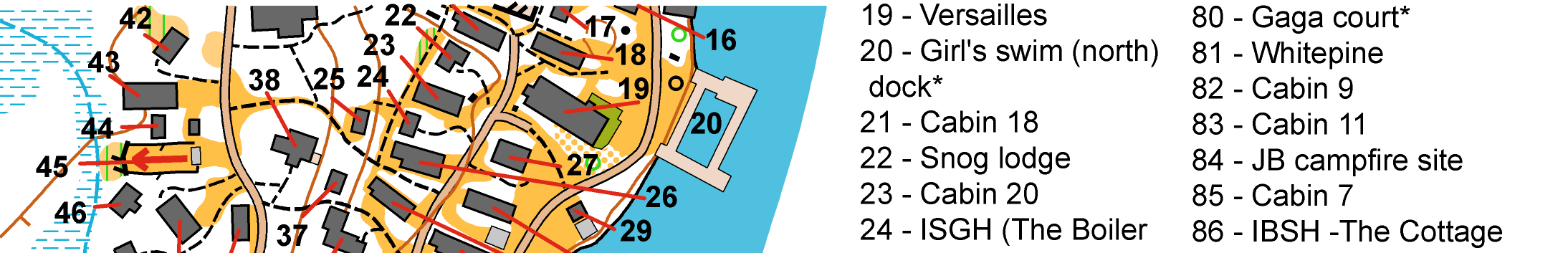
While
I was there, the owners asked me if I could build a "locator" map of
the camp. Working with the camp counselors, we identified 121 buildings
or activity areas like the zip line and climbing wall. Placing all the
codes and pointers onto the orienteering map, building the index and
completing the final drawing took the better part of a day. Using the
"hide symbol" option in OCAD I was able to build one master map that
could be used as an orienteering map or, with a few clicks and
two drags, a locator map for campers and visitors.
I also produced a simple canoe-O map of the lake that included the docks
along the camp shore, small bays, and a few other features that I could
extract from the government topo.
Ed
Hicks, who is a distributor of OCAD, provides his clients with a copy
of the software as part of each contract. The counselors were keen to
learn how to use OCAD so they could make map corrections themselves and
draw their courses. In a couple of hours they were happily moving
buildings around and plotting adventures for their campers. I left the
camp satisfied that the map would be well used and maintained.